Trimble Dual R10 RTK GNSS Receiver and TSC3

Trimble Dual R10 RTK GNSS Receiver and TSC3

$8,800

Contact Us

Trimble Dual R10 RTK GNSS Receiver and TSC3 with access kit.
New Level of Productivity, Collect more accurate data faster and easier – no matter what the job or the environment, with the Trimble R10 GNSS System.
The R10's combine powerful features and groundbreaking technologies including Trimble HD-GNSS, Trimble SurePoint, Trimble 360, and Trimble x

manufacture: 2012
Condition: Used, still like new, no scratch, 15 months old
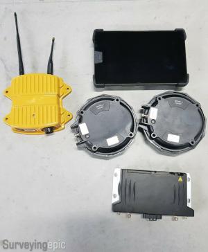
the base and rover have 450-470mhz frequency internal radio's with UHF Transmit (TX), also currently programmed at 12.5khz (So you would be FCC compliant)
These unit's also have the 20hz update rate option enabled which makes them extremely fast.

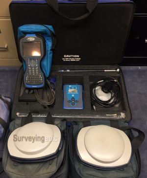
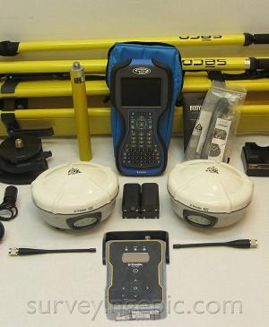
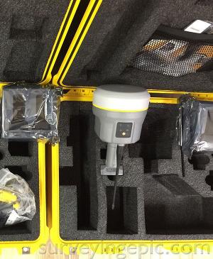
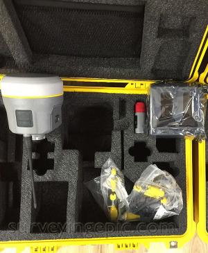
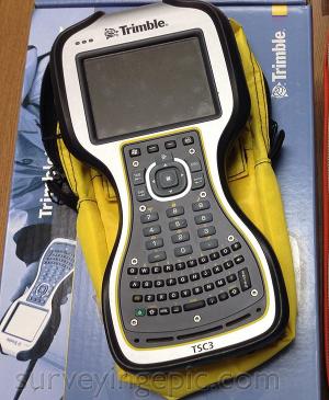
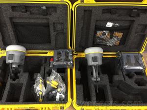
Trimble Dual R10 RTK GNSS Receiver and TSC3 Includes:
- 1X Rover: Trimble R10 Rover, 20hz update rate, Dual frequency L1, L2, L2c, L5, Galileo, GNSS Bluetooth, RTK capable, 450-470mhz internal RX/TX radio
- 1X Base: Trimble R10 Rover, 20hz update rate, Dual frequency L1, L2, L2c, L5, Galileo, GNSS Bluetooth, RTK capable, 450-470mhz internal RX/TX radio
- 1X TSC3  with access software
- 2X dual bay charger,
- 6X batteries
- 2X whip antenna
- charging cables
- USB cables
- 2X hard carrying case
- 12 month warranty on R10 and TSC3 (fresh calibration certification and manufacture warranty).

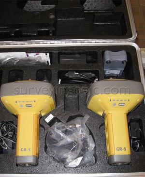
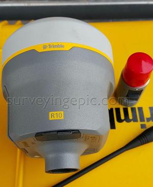
Trimble R10 GPS GNSS Receiver, Integrated Antenna, Receive and Transmit UHF Radio, 8 mm H / 15 mm V Max. Precision, 672 Channels, Integrated Antenna, Receive & Transmit UHF Radio

Collect more accurate data faster and easier – no matter what the job or the environment, with the Trimble R10 GNSS System. Built with powerful technologies integrated into a sleek design, this unique system provides surveyors with a powerful way to increase data collection productivity in every job, every day.

  • Powerful 672-channel solution with Trimble 360 technology delivers the most advanced satellite tracking
  • Improved protection against sources of interference and spoofed signals
  • Connect to Android or iOS mobile devices running supported apps via Bluetooth®
  • Cutting edge Trimble HD-GNSS processing engine enables surveyors to measure points more quickly
  • Trimble SurePoint fully compensates for pole tilt. Conveniently measure points that were otherwise inaccessible with complete quality assurance
  • Trimble CenterPoint RTX delivers GNSS corrections via satellite or internet connection anywhere in the world with unprecedented speed and accuracy for a PPP solution
  • Trimble xFill ensures less downtime in the field, with continuous RTK coverage during connection outages from an RTK base station or VRS network
  • Ergonomic design for easier and more comfortable handling
  • Integrates seamlessly with the Trimble SX10 scanning total station and S-Series total station positioning sensors
  • Pair with Trimble Access and the TSC7, TSC3, Slate or Trimble CU controller for the most powerful land surveying equipment solution on the market

Pure, uninterrupted surveying

  • With a Trimble CenterPoint RTX subscription, enhanced Trimble xFill functionality allows surveyors to continue collecting data with centimeter accuracy indefinitely after connection is lost with their base station or VRS network.
  • Without a Trimble CenterPoint RTX subscription, xFill maintains RTK level accuracy for up to five minutes during interruptions in the primary terrestrial correction stream. xFill functionality is built into every Trimble R10 GNSS system.

Collect more accurate data faster and easier

  • Survey previously inaccessible points, reduce occupation time and record faster and safer measurements than ever before.
  • Built-in firmware gives automatic compensation for up to 15 degrees of pole tilt.

Trimble software designed for surveyors

  • Bring the power and speed of the Trimble R10 system together with trusted Trimble land surveying software solutions, including Trimble Access and Trimble Business Center.
  • Trimble Access field software provides specialized and customized workflows to make surveying tasks quicker and easier while enabling teams to communicate vital information between field and office in real time. Back in the office, users can seamlessly process data with Trimble Business Center software.


Trimble Integrated GNSS Systems Comparation

  Trimble R10 Trimble R8s Trimble R2 Trimble R1
Max. Precision 8 mm Horizontal / 15 mm Vertical 8 mm Horizontal / 15 mm Vertical 10 mm Horizontal / 20 mm Vertical 50 cm
RTK Compatible Yes Yes Yes No
Channels 672 440 220 44
Antenna Integrated Integrated Integrated Integrated
UHF Radio Receive & Transmit Receive & Transmit Receive --
xFill Yes No No No
Memory 6 GB 56 MB 48 MB --
Cellular Yes Available External External
Satellites GPS, GLONASS, Galileo, BeiDou, SBAS Based on configuration GPS, GLONASS, Galileo, BeiDou, SBAS GPS, GLONASS, SBAS, BeiDou, Galileo